
Centre for Fine Arts, BOZAR Brussels, installation view, 2020

European Commission's Joint Research Centre, Italy, installation view, 2019


Centre for Fine Arts, BOZAR Brussels, installation view, 2020

European Commission's Joint Research Centre, Italy, installation view, 2019
B-scope
Two-channel HD + low res video, audio,
12minutes 31 seconds
Monitors, acrow props, real-time ocean wave forecast datasets courtesy of ECMWF, UK
2019
Datami Resonance Festival III
curated by Freddy Paul Grunert
European Commission
Joint Research Centre,
Ispra,
Italy
October 14th - November 8th 2019
BOZAR Centre for Fine Arts,
Rue Ravenstein 23,
1000 Bruxelles,
Belgium
10th December - 19th January 2020
B-scope is a two-channel HD + low res video and audio artwork. The video features footage taken by the artist during an artist’s residency aboard the research vessel The Celtic Explorer in the North East Atlantic Ocean. The opportunity also enabled her to capture video footage from the survey’s underwater Remotely Operated Vehicle (ROV) cameras. The underwater vehicle, physically linked to the host ship by an umbilical cable, descends and ascents to/ from the ocean floor. In this manner, the artwork is an inquiry into vertical perspectives – journeying above and below the horizon line - as a counterpoint to the more familiar horizontal perspectives that explore life on Earth’s crust and its lived atmosphere. The camera acts as a sensor, giving humans the opportunity to spectate the hostile ocean floor, and providing detailed on-the-ground information to corroborate distantly gathered data.
The ROV dive featured in B-scope took place on 15th May - a date that inadvertently aligns the expedition with four other significant journeys of exploration. These explorations, contributing to the Space Race, included the Soviet Union’s launch of Sputnik 3 in 1958 and Sputnik 4 in 1960, the USA’s launch of Mercury-Atlas 9 in 1961 and the Soviet Union’s launch of the Polyus spacecraft in 1987 (all launched 15th May). This shared launch date links the European expedition’s dive and its location in the Atlantic with historical expeditions that also journeyed perpendicularly to the horizon, albeit in the opposite direction. In addition, the video contains ocean wave forecast for the dive’s precise location on 15th of May, 2019.
B-scope was developed in collaboration with Dr Florian Pappenberger, Director of Forecasts, The European Centre for Medium-Range Weather Forecasts, UK and Dr Aaron Lim, University College Cork, in association with Parity Studios and The Irish Centre for Applied Geoscience (iCRAG), University College Dublin through the Monitoring Changes in Submarine Canyon Coral Habitats Marine Expedition, North East Atlantic Ocean, 2019.
Kindly commissioned by The European Commission (2019) & supported by An Arts Council of Ireland’s Travel & Training Award (2019).

Centre for Fine Arts, BOZAR Brussels, installation view, 2020

European Commission's Joint Research Centre, Italy, installation view, 2019

European Commission's Joint Research Centre, Italy, installation view, 2019
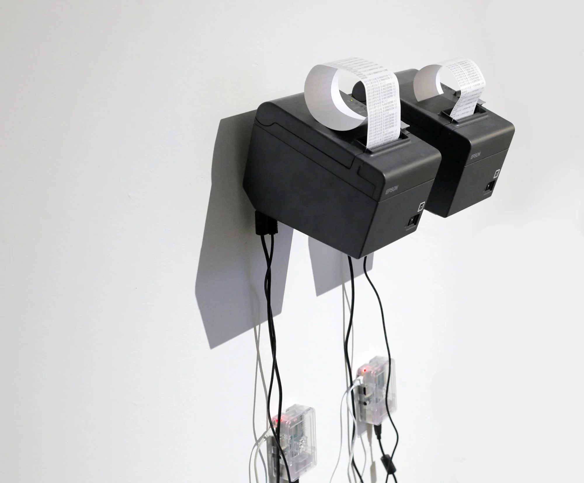
C-index
Thermal printer, raspberry pi, real-time tsunami warning system (IDSL) Inishmore datasets courtesy of the Joint Research Centre, Ispra, Italy
2019
C-index, a corresponding HD video artwork to B-scope, explores the infrastructure, big data and governance of early warning systems for rising sea levels and location-specific hazards, such as tsunamis. In particular, this artwork focuses on Ireland’s first Inexpensive Device for Sea Level Measurement (IDSL) that was recently installed on the island of Inishmore, on Ireland’s west coast in the North East Atlantic Ocean.
C-index was developed in collaboration with Dr Alessandro Annunziato, Daniele Galliano & Thomas Petroliagkis, The European Crisis Management Laboratory, Joint Research Centre, Italy.
Kindly commissioned by The European Commission (2019)
