
Network glitches & forest walks:
a remote-sensed response to Martina O’Brien’s of ephemeral measure*
Kate Lewis Hood Research Associate, Smart Forests
* This response was delivered virtually at the of ephemeral measure: volume I publication launch at the Dublin Art Book Fair at Temple Bar Gallery, Dublin, on 28 November 2022.
Accessing of ephemeral measure through digital files, and speaking to you this evening in the late November dark over Zoom, I’ve been thinking about how we might remote-sense this sensing project – from a distance, through data servers and undersea cables.
More specifically I’m approaching of ephemeral measure digitally and remotely via the Smart Forests Atlas, which is an online platform that gathers together scientific, artistic, activist, and community projects that are using technology in forests, and explores the social and political aspects of these technologies. The Atlas engages different projects through a range of media, including critical discussion, stories, interviews, images, sound, and mapping.
In this context, this evening I’m locating of ephemeral measure amongst a network of scientific and artistic projects that use different technologies to make and measure phenological data. Phenology is concerned with the timing of recurring events in plant and animal life and climate cycles, which Dr Alison Donnelly discusses in more depth in the publication. While of ephemeral measure is in part an intervention into the lack of sustained phenological data collection in Ireland – which is especially important in the context of climate change – O’Brien prompts us to question how, where, and why environmental data are produced and accumulated, and what knowledges and relationships are made through these processes. In locating of ephemeral measure amongst a network of phenological projects, I want to suggest that O’Brien’s work asks questions about what constitutes a network, how they make environments sense-able, and what they might elide or obscure.

The ’Phenology’ tag on the Map wayfinder of the Smart Forests Atlas, https://atlas.smartforests.net/en/map/?filter=phenology
If we select the ‘Phenology’ tag on the Map of the Smart Forests Atlas, we can see a range of locations (shown with yellow dots) where phenological monitoring projects are taking place; for example, in the US, Italy, Finland, Japan, and of ephemeral measure in Ireland. Most of these are scientific projects with high levels of institutional funding, technological equipment, and data infrastructures.

Kate Lewis Hood, Phenology: Science, Technology, and Art logbook, Smart Forests Atlas (2022), https://atlas.smartforests.net/en/logbooks/phenology-technologies/
This includes the PhenoCam network that Martina introduced me to, which is a large-scale project that started in experimental research forests in the northeastern United States and has now spread globally. The PhenoCam network allows users anywhere in the world to log in and access regularly updated and archived images from cameras installed mainly in forests, and also to contribute images (if they have suitable equipment). Interestingly, because of the cost and energy use of maintaining a large data management infrastructure, the PhenoCam network recently limited image processing and archiving services to two cameras per research group. This rule implicitly assumes that people contributing phenological data will be scientists in established research teams rather than everyday people or artists, for example.
By contrast, I can’t access automatically-updated imagery from of ephemeral measure. As O’Brien writes in her essay in the publication, she acts as the ‘embodiment of the network’, moving between cameras that don’t always function, that produce unreadable data, that glitch and err and blur. Here my aim is not to present PhenoCam and of ephemeral measure as opposites in the ways they approach environments, technologies, and data. Rather, I suggest that O’Brien’s project lingers with the embodied labour and material contingency of data-making – from technologies of measurement to access to land and relationships with those who live and work on it, navigating data regulations, and responding to more-than-human agencies and disruptions from animals, technologies, weathers.
In her book Program Earth, Jennifer Gabrys writes:
By sensing environmental conditions as well as detecting changes in environmental patterns, sensors are generating stores of data that, through algorithmic parsing and processing, are meant to activate responses, whether automated or human-based, so that a more seamless, intelligent, efficient, and potentially profitable set of processes may unfold. (Gabrys 2016: 8)
of ephemeral measure asks us to pause, to stay in the not-quite-efficient, the entangled and potentially unprofitable. What are sensors and sensing for then?
Martina O’Brien, of ephemeral measure (2021)
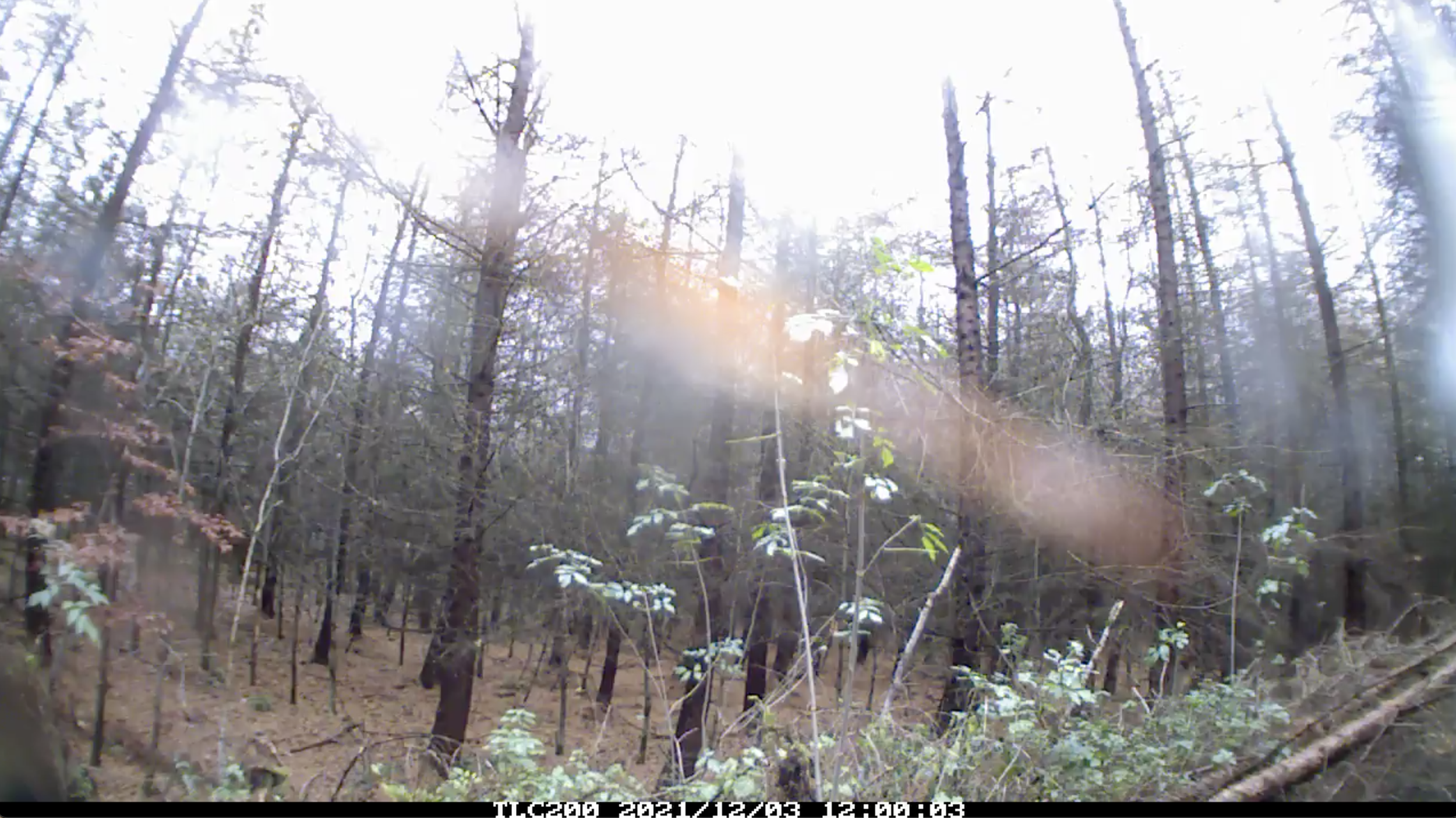
remote sensing notes: 21/11/22
It’s raining and I’m looking at the images Martina sent over from the plantation forest that is one of the monitored sites in of ephemeral measure. The images all have the same timestamp – 12:00:03 – and some of them were taken almost a year ago, in December 2021. In the stark winter light, even the evergreen pine trees look bare and the image is smudged with rainspatter; in brighter sun, the images blear and glow. The most recent image – from June 2022, the trees filled out with summer – has a multi-coloured glitch in the bottom right-hand corner. This is a ‘recurring timestamp malfunction’, Martina tells me in an email, and as I leaf back and forth through the images in my Downloads folder I try to picture this wayward camera through which the timing of phenological events is both precisely recorded and always on the brink of becoming ‘bad data’.

Martina O’Brien, of ephemeral measure (2021)
Questions for Martina: Compared to scientific projects that often need to control as many variables as possible to produce knowledges that are institutionally recognised as valid, how are you thinking about of ephemeral measure’s possibilities to stick or stay with ‘bad data’? How do you see your role as an artist maintaining and caring for this potentially errant network?
We can also locate of ephemeral measure in relation to other creative projects are reworking scientific technologies and processes of sensing environments.

Michelle Westerlaken, Hyytiälä Foresty Field Station logbook, Smart Forests Atlas (2022), https://atlas.smartforests.net/en/logbooks/hyytiala-forestry-field-station/
remote sensing notes: 13/11/22
In the middle of a Sunday in the UK and Ireland, and later in the afternoon in Finland, I (and also Martina) join a hybrid Zoom walk with the Open Forest Collective, a group of creative researchers and practitioners who work and walk together in Hyytiälä Forestry Field Research Station in Finland. Since 1995, the station has been continuously measuring ecosystem and atmospheric interactions in the forest.

Jaz Hee-jeong Choi, Lachlan Sleight, Andrea Botero, and Markéta Dolejšová, Hyytiälä (SMEAR II) on Feral Map, https://feral-map.vercel.app/?loc=aalto
On the walk, Open Forest Collective members Andrea Botero and Markéta Dolejšová become another ‘embodiment of the network’ (in O’Brien’s terms) as they take us around the forest with them. Andrea holds up a laptop that quickly runs out of power and has to be changed for another one, and tells us about the forest’s sensors, data servers, and out-of-season berries. Markéta, with a phone, zooms in on the foil casserole dishes used to protect equipment strapped onto trees, the can used to cover a measuring instrument on the forest floor, and the objects that physical participants have brought with them as prompts and reminders of how they conceptualise forests. The Collective and physical participants describe the perpetual hum of the hooked-up forest, but the Zoom background noise suppression prevents us from hearing it, even when Markéta goes close to the source of the noise. These sensory data are unavailable to us remotely; what we have to rely on are stories and other, more subtle signs – for example, the lack of animals in the forest, because many of them are put off by the sound. Afterwards, we are invited to share our experiences and stories – from the forest, from our distanced sites – on a digital Feral Map.

Martina O’Brien, of ephemeral measure (2022)
The images in of ephemeral measure are ostensibly silent, although they too bear other indications of the noise of their atmospheric conditions, weathers, and technological mediations as incremental, quotidian differences. Perhaps less immediately perceptible is that the images we see are also produced by walking, mostly by O’Brien herself in installing, maintaining, and collecting data from the cameras, but also other people through the ‘walkshops’ O’Brien hosts. From the images I can see remotely, these walkshops open up the terrains and textures of environmental monitoring, and foreground the intersections of social, technological, and ecological interactions that range from reaching to put up a camera or stumbling over heather to the play of light and shadow from tree branches on the backs of participants’ necks and shirts. Perhaps what of ephemeral measure offers, in its various forms of documentation, is a kind of shadow-sensing of the sensing, the obstacles and shapes of interaction in the messy production of data.
Questions for Martina: What role do you see the walkshops playing in of ephemeral measure? Do you see the project as part of a network, or perhaps creating a network – even if it is quite different from big projects such as the PhenoCam network? How do you see the project growing and evolving in its second year?
Kate Lewis Hood, 28 November 2022